


By Tobin Fitzthum
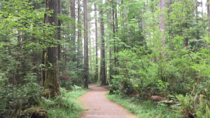
![]() When the one-mile section the Chehalis Western Trail reopens, there is no better way to celebrate then riding the entire trail. Most riders start at the Woodard Bay trailhead near a heron rookery that is closed during most of the summer and the recently renovated Woodard Bay Conservation Area. From there the trail cuts through beautiful Thurston County for more than 20 flat miles.
When the one-mile section the Chehalis Western Trail reopens, there is no better way to celebrate then riding the entire trail. Most riders start at the Woodard Bay trailhead near a heron rookery that is closed during most of the summer and the recently renovated Woodard Bay Conservation Area. From there the trail cuts through beautiful Thurston County for more than 20 flat miles.
However, when you get to the end of the Chehalis Western Trail, most riders realize that the biggest logistical challenge involves not riding 20 miles but rather coordinating how to get home.
Riders should arrange to be either dropped off or picked up by someone not making the journey whose car can fit bicycles. Although the trail is technically 21.5 miles long, riders should expect to travel farther than that because the end of the Chehalis Western Trail is not at a trailhead. Rather the trail meets in a T with the Yelm-Tenino Trail which, unsurprisingly, connects Yelm and Tenino. There are places in either direction where riders can meet the road and a car coming to pick them up within a mile, but perhaps the best way to end the trip would be to take the trail to Tenino.
The additional 6.5 mile ride to Tenino will make the total distance 28 miles, but it’s worth it to emerge at the Tenino Quarry Pool which is open for swimming until early September. The 28-mile trip should take about three hours with an average speed of ten miles an hour.
Additionally, there are many possible stops along the way such as the Monarch Contemporary Art Center and Sculpture Park which is located along side the trail as few miles from its terminal junction.
Want to ride sooner?
If the Chehalis Western Trail doesn’t open soon enough for you, there are other options for longer bike throughout Thurston County. One of the many great things about bicycles is that they will do fine on just about any road. For many people, however, riding on the road or even on the shoulder, is much more daunting than riding on a trail intended for bicycles. Fortunately there are routes for just such riders throughout the county although none are as extensive as the Chehalis Western Trail.
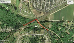
One of the most obvious options for biking when the Chehalis Western Trail is closed is simply using other parts of the trail. Unfortunately it is difficult to detour around the 1 mile section of trail closed for trestle replacement and impossible to do so without traveling on the road. But as the closure is about ten miles from the Woodard Bay trailhead, it still makes for a good ride to start from Woodard Bay and ride to the section that is closed and back again.
Additionally there are several trailheads after the roadwork including those on Waldrick Road. This section of the trail is just under ten miles long and follows the Deschutes River for many stretches.
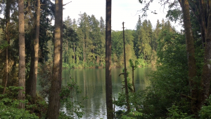
Another alternative is to use the Yelm-Tenino Trail. In total, the route is 14 miles long and passes over the Deschutes River and by McIntosh Lake.
Getting away from the Chehalis Western Trail entirely, there are other paved options throughout the county. In West Olympia, for example, there is a nice bike path near The Evergreen State College. The best trailhead is probably on 17th Avenue off of the Evergreen Parkway. There is parking on either side of the road just after the turn and the trail goes both North and South.
Heading north will take riders along the parkway to Mud Bay Road. There riders will have to ride briefly on the shoulder as they head east towards one of two options. The first trail is visible from Mud Bay Road and snakes up onto an overpass that takes riders to McLane Elementary. From there riders can loop back around to the first path. This route, however, is only a few miles.
The second route begins further along Mud Bay Road. Riders should take a left on Overhulse. There, a trail similar to the first begins and travels along the other side of the parkway. This trail is older and has some bumps from roots that have grown under the asphalt. At 17th Avenue, riders can either cross Evergreen Parkway to return to their cars or continue on the trail on the other side of 17th. There the trail meets with the protected bike shoulder on the Evergreen Parkway. Riders can follow this to the roundabout at the official entrance to the college where it is easy to cross the road and head back along the other side to the first trailhead.
Another alternative is the Woodland Trail which is one of the newest trails in the area. From the trailhead on Eastside Street, the Woodland Trail takes riders to a roundabout where they can meet with the Chehalis Western Trail as it approaches Chambers Lake Park or continue through Lacey.
For other possible routes or more information about the aforementioned choices, check out Thurston County’s interactive bike map.


